Historical atlas · Map guide
Map of Europe in 1914
This interactive map opens on 1 January 1914, before the outbreak of World War I. Explore European borders, select a country to inspect its historical period, or change the timeline to compare a later year.
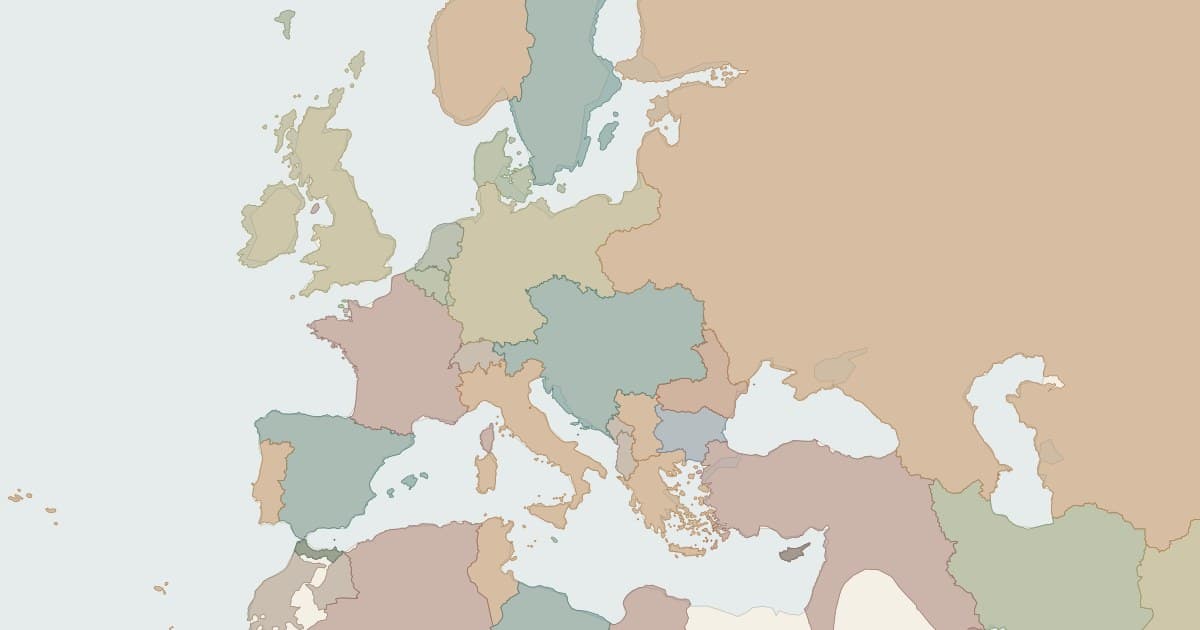
Read the borders before World War I
Explore political territories at the start of 1914. Colors distinguish territories on the map. Click a colored area to see its name and historical period, then zoom in to follow its border.
The map starts in January rather than treating all of 1914 as a single moment. Keep the month and day visible when comparing records. A country can have more than one boundary stage in the same year, and changing the year alone can miss those transitions.
Compare the map of Europe in 1914 and 1919
Keep the European view fixed, enter 1919 in the Year field, and compare the outlines with the January 1914 view. Inspect the records on both dates to distinguish a changed border from a gap in the dataset. Use the change controls to find the recorded transitions between the two views.
For a closer comparison, select a territory and read its start and end dates. Keep the map camera fixed while changing the date to compare the same frontier across different periods.
Territories in this starting view
Explore these territories at this page's starting date. The Countries layer contains 186 active territory records worldwide at this date.
| Territory | Recorded start | Recorded end |
|---|---|---|
| German Reich | 1890-07-01 | 1918-11-11 |
| Austria-Hungary | 1908-10-06 | 1918-10-31 |
| Russian Empire | 1908 | 1914-04-17 |
| French Republic | 1890 | 1918-11-22 |
| United Kingdom of Great Britain and Ireland | 1801-01-01 | 1922-12-04 |
| Ottoman Empire | 1913-05-30 | 1918-10-30 |
How to use the historical map
- Enter a year and choose CE or BCE. Set the month and day when you need a particular date.
- Choose a region or drag the map to the area you want to investigate.
- Search for a territory and open its details. Enable All periods to search outside the current date.
- Move the timeline, play it automatically, or jump to the previous or next recorded boundary change.
- Use Share view to copy the current date and camera. Export GeoJSON to download the active records in the selected layer.
Questions about historical maps
What is a historical map?
A historical map represents geography at a specified past date or period. This atlas reconstructs recorded political boundaries on a modern coastline. It is a dated border viewer, rather than a collection of scanned maps printed in the past.
How do I see country borders in a particular year?
Enter the year, choose CE or BCE, and set the month and day. The map displays records whose start date has been reached and whose end date has not yet been reached. Use the region controls to move the camera without changing the selected date.
Which years does the timeline cover?
You can choose dates from 8000 BCE through 29 September 2026. Use Ancient, Pre-modern, Modern, or All time to change the timeline range, then enter a year or drag the timeline to explore a particular date.
Can I download the historical map as GeoJSON?
Yes. Use Export GeoJSON for the current date to download the territories displayed in the selected country or empire layer. Choose the date and layer before exporting to save that view's boundaries.